Looking for an extension activity for your weather and climate unit? Do you need a straightforward activity that students can complete without too much teacher assistance? If you answered yes to either of these questions, then this ocean currents webquest is the perfect activity!
What is covered in this resource?
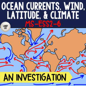
- Major global ocean currents
- Map analysis skills
- How ocean currents affect regional climates
- gyres
- The Great Pacific Garbage patch (ecology connections)
Tips for using this resource:
Personally, I would advise printing at least the map portion of this resource. Students will need red and blue colored pencils or markers to complete the map on paper. You can provide students a map of the ocean currents to copy, or leave it up to them to research on their own.
For the webquest portion of this resource, students will need to access two different websites to investigate the Great Pacific Garbage Patch and how it connects to the environment and ocean currents.
Who is this resource for?
This resource can be used by classroom teachers, tutors, and parents of students in grades 6-9. It comprehensively covers the topics mentioned, and provides opportunities for student responses which can be implemented in a whole group lesson or assigned for homework. Ideal for classrooms with internet access and student devices.
How Can I Use this Ocean Currents Webquest?
- Emergency Sub Plans
- An independent work station in a set of stations
- Flipped Classroom pre-reading
- Whole or small group opportunity to model and teach Close Reading strategies and annotation
- Differentiation – Assign this webquest as reteaching for students who have yet to show mastery.
- Homework
- Creation of Independent Work Packet for students who are not able to be present for direct instruction.
- Extension activity for early finishers or for students who show a special interest in the topic
- Use as a square on a Choice Board
- Interactive Notebooks: Print 2 pages in one and cut apart. Glue mini pages into notebooks with room for annotations on the side
- Interactive Notebooks: Print entire PDF as a mini booklet and add to notebooks using these simple instructions.
What’s Included?
Purchase includes a printable PDF file in color. On page 2 of this resource you will find a link to a student friendly Google Slide version of this file. You will be able to copy this file and use it with Google Classroom or any other paperless initiative.
Please take a look at the preview file to see more of this resource.
———————————————————————————————————–
More questions?
Check out our Frequently Asked Questions or email me at laneyleeteaches@gmail.com.
Get more value by becoming a member! 
Join our membership to gain access to my entire catalog of resources for FREE!
My store features 3 full-year middle school science curriculums comprised of over 22 units of study.
Each and every unit comes includes the following:
- A unit guide complete with key vocabulary, suggested pacing, essential questions, and more!
- Google Slides presentations to cover major topics, with guided notes for students!
- Reading Comprehension activities with follow up questions. These resources are useful for homework, classwork, sub plans, and more!
- Assessment: Pretest, study guide, CERs, and final assessment.
- Projects and labs
- Webquests, color by number, stations, and other practice activities.
Click below to learn more about how to sign up!
Join monthly.
Join yearly.
———————————————————————————————————–
NGSS Standards covered by this Ocean Currents Webquest:
Develop and use a model to describe how unequal heating and rotation of the Earth cause patterns of atmospheric and oceanic circulation that determine regional climates. Emphasis is on how patterns vary by latitude, altitude, and geographic land distribution. Emphasis of atmospheric circulation is on the sunlight-driven latitudinal banding, the Coriolis effect, and resulting prevailing winds; emphasis of ocean circulation is on the transfer of heat by the global ocean convection cycle, which is constrained by the Coriolis effect and the outlines of continents. Examples of models can be diagrams, maps and globes, or digital representations. Assessment does not include the dynamics of the Coriolis effect.